


Sverige Topo Kartan

Opis Sverige Topo Kartan
Aplikacja do nawigacji GPS do użytku wewnątrz i na zewnątrz, łatwa w użyciu z dostępem do najlepszych map topograficznych i zdjęć satelitarnych Szwecji.
Funkcje ++ PRO są potrzebne do użytku w trybie offline! ++
Zmień swój smartfon / tablet z Androidem w zewnętrzny odbiornik GPS do podróży w słabo zaludnionych obszarach BEZ POKRYCIA KOMÓREK. Ta aplikacja zapewnia podobne opcje mapowania, do których jesteś przyzwyczajony z telefonami GPS firmy Garmin lub Magellan.
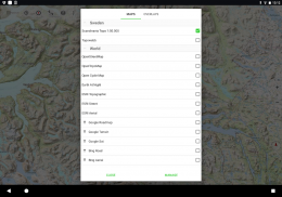
Zawiera BEZPŁATNE miejsce na mapy:
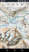
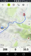
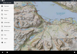
• Mapa topograficzna 1: 50 000 dla Skandynawii (Dania, Norwegia, Szwecja i Finlandia) z cieniowaniem gór. Mapa terenu Lantmateriet + mapa górska
• Topowebb: Lantmateriet Mapa topograficzna Szwecji
• OpenStreetMaps: te mapy crowdsourcingowe są bardzo przydatnym dodatkiem do innych warstw map i zawierają wiele unikalnych funkcji
• OpenCycleMaps: te mapy są idealne do planowania wycieczek rowerowych (tylko użytkownicy PRO)
• Topografia ESRI
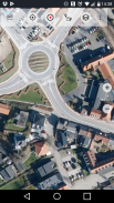
• Zdjęcia lotnicze ESRI
• Mapa drogowa ESRI
• Mapa drogowa Google (tylko dostęp online)
• Obrazy satelitarne Google (tylko dostęp online)
• Mapa terenu Google (tylko dostęp online)
• Bing Roadmap (tylko dostęp online)
• Obrazy satelitarne Bing (tylko dostęp online)
• Ziemia w nocy
• Nakładka cieniowania skał
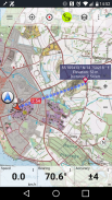
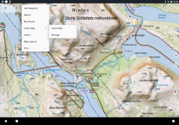
Główne funkcje nawigacji do użytku na zewnątrz:
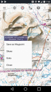
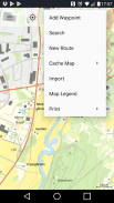
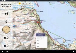
• Twórz i edytuj punkty trasy
• Przejdź do nawigacji z punktami drogi
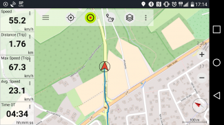
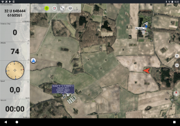
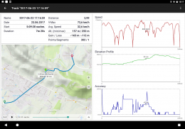
• Zapis trasy (z profilem prędkości, wysokości i dokładności)
• Tripmaster z polami do pomiaru odległości, średniej prędkości, namiaru, wysokości itp.)
• Eksport GPX / KML / KMZ
• Szukaj (nazwy miejsc, POI, drogi)
• Konfigurowalne pola danych w widoku mapy i Tripmaster (np. Prędkość, odległość, kompas ...)
• Udostępniaj punkty, ślady lub trasy (przez e-mail, Whatsapp, Dropbox, Facebook ...)
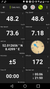
• Zobacz współrzędne w formacie Lat / Lon, UTM lub MGRS / USNG (wojskowy system odniesienia sieci / amerykańska sieć krajowa)
• Nagrywaj i udostępniaj trasy ze statystykami i profilami wysokości
• Obracanie mapy (śledzenie i śledzenie)
• Uzyskaj wysokość i odległość, klikając długo na mapie
• Odtwarzanie ścieżki
• Dodaj własne serwery map
• I wiele więcej ...
Dostępne dla wersji PRO: (funkcje Pro dostępne do zakupów w aplikacji)
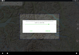
• Praca w trybie offline - nie jest wymagany zasięg sieci komórkowej. Brak opłat roamingowych!
• Łatwe i szybkie masowe pobieranie map do użytku w trybie offline (nie dotyczy map Google i Bing)
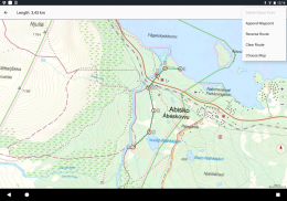
• Tworzyć i edytować trasy
• Nawigacja po trasie (nawigacja punkt-punkt)
• Import / eksport GPX / KML / KMZ
• Nieograniczona liczba punktów i ścieżek
• Dodaj inne serwery map
• Bez reklam
Praca w trybie offline:
Wszystkie wyświetlane pola mapy są przechowywane w pamięci podręcznej. Aby buforować duże obszary, musisz kupić funkcje Pro.
Użyj tej aplikacji nawigacyjnej do zajęć na świeżym powietrzu, takich jak piesze wycieczki, jazda na rowerze, biwakowanie, wspinaczka, jazda konna, jazda na nartach, kajakarstwo, polowanie, wycieczki terenowe 4WD lub ratownictwo morskie (SAR).
Dodaj niestandardowe punkty trasy w formacie długość / szerokość geograficzna, UTM lub MGRS / USNG z datami WGS84.
Importuj / eksportuj / udostępniaj punkty / ścieżki / trasy GPS w formacie GPX lub Google Earth KML / KMZ.
Wstępnie załaduj BEZPŁATNE dane map dla obszarów, które nie mają zasięgu komórkowego (funkcja Pro).
Komentarze i prośby są wysyłane na adres swedenmaps@atlogis.com
Spójrz na nasze inne aplikacje do nawigacji na świeżym powietrzu:
https://play.google.com/store/search?q=atlogis
++ Nie śledzimy aktywności użytkowników ani nie zbieramy danych użytkowników! ++
Sverige Topo Kartan - Wersja 7.8.1
(19-05-2025)
Sverige Topo Kartan - Informacje APK
Wersja APK: 7.8.1Pakiet: com.atlogis.swedenNajnowsza wersja Sverige Topo Kartan
Inne wersje


Apki w tej samej kategorii


Mogą Cię się spodobać...


